Tag Archives: environmental history

Indiana’s Pearl and Button Boom

[This post originally appeared on Hoosier State Chronicles: Indiana’s Digital Newspaper Program]

Today, we drive over rivers and creeks in a few seconds and barely know their names.  But before modern transportation severed so much of our connection to waterways, human contact with rivers practically defined life in water-rich Indiana.

One lost industry that had a brief “boom and bust” over most of the eastern U.S. a century ago was closely tied to the life of the rivers.

If you’re keeping a list of industries (like steel and auto manufacturing) that have declined and even vanished from the Midwest, add one more:  pearl button making.

Consumers today rarely give a thought to where buttons come from.  How synthetic goods are made (i.e., the zippers, plastic buttons, and Velcro that partly replaced shell around 1950) may seem less “romantic” than the work of pearl fishermen hauling shiny treasures out of Midwestern streams in johnboats.  Yet in spite of its nostalgic appeal, the pearl button industry also wreaked havoc on the environment and workers in factories.


wabash river pearl hunter vincennes indiana circa 1905

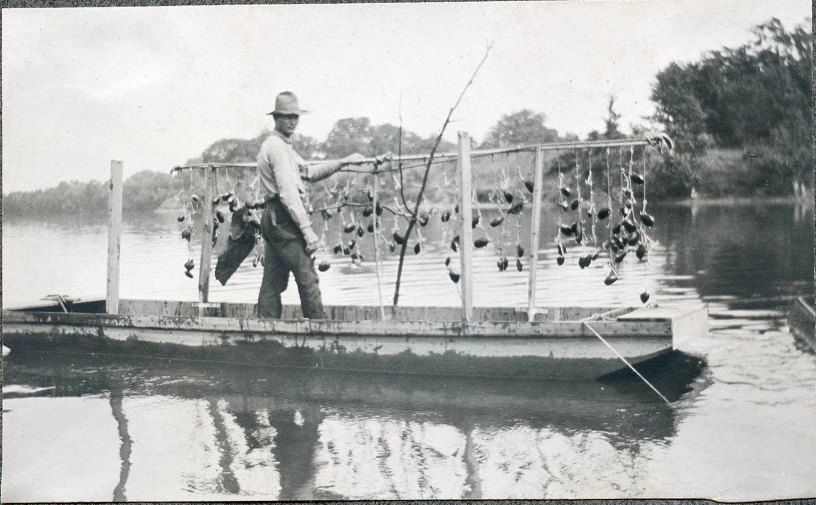
(This photo taken on the Wabash River at Vincennes, Indiana, around 1905 shows a pearl fisherman in his boathouse.  He kept a “cooker” on hand to steam the mussel shells open.  “The meat was fed to hogs or used as bait.”  Shells were sent off to button factories.)


rock river clamming near Beloit WI ca 1911 Lloyd Ballard

(Man on a johnboat on the Rock River outside Beloit, Wisconsin, circa 1911.  Mussels would clamp down on hooks and not let go until they were cooked off.  The rods were often made out of cast-off gas pipes.  Photo by Lloyd Ballard.  Beloit College Archives.)


At the time of European settlement, Midwestern rivers abounded in mussels.  As many as 400 species probably lived in the Ohio Valley in 1800.  The Mound Builder cultures that once occupied the American heartland found many uses for mussels and left behind enormous refuse piles (what archaeologists call middens) in their towns, which almost always sat beside creeks and rivers.  (And they were large towns.  In the year 1200, Cahokia, across the Mississippi River from St. Louis, was bigger than medieval London.)

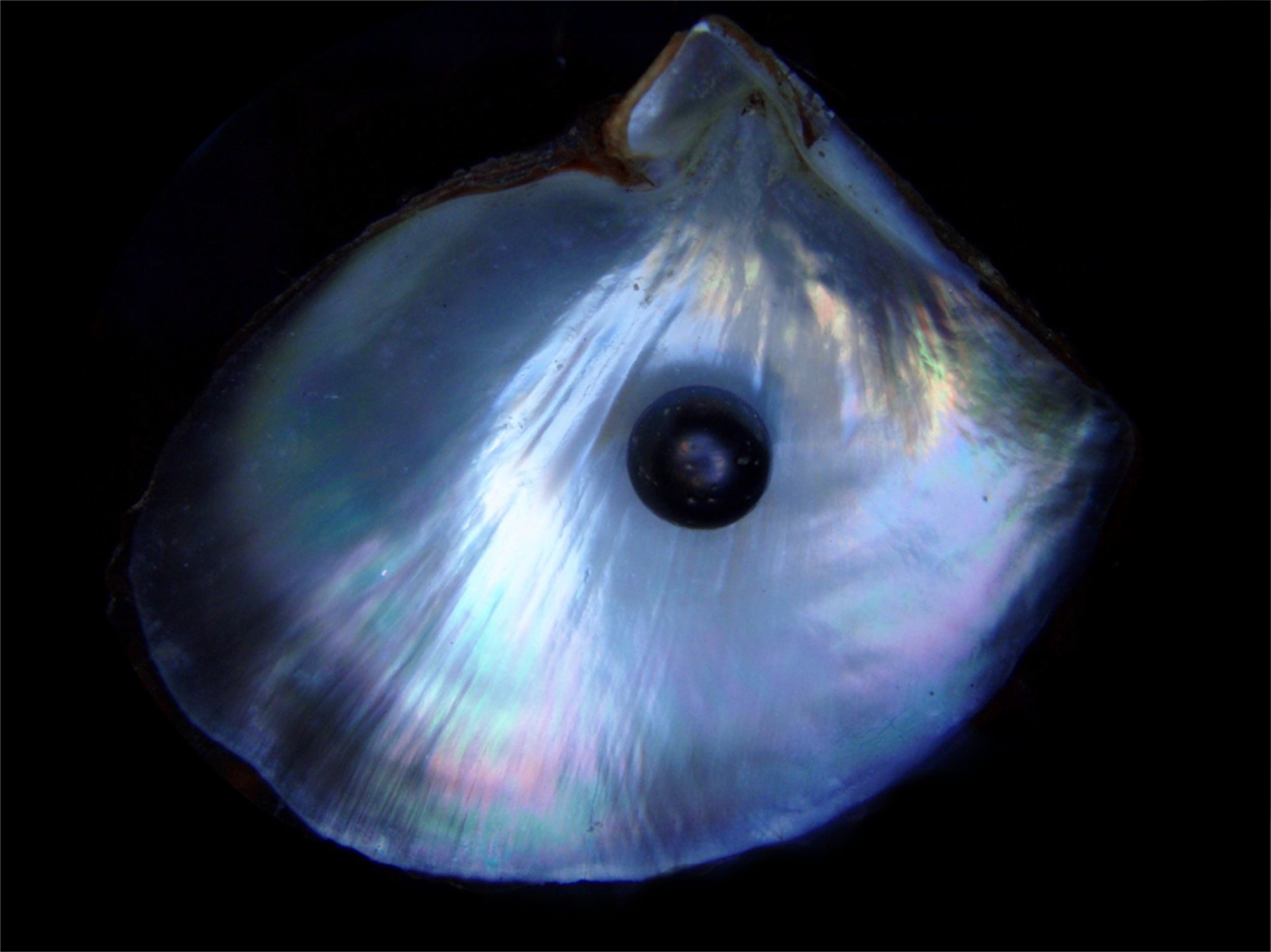
Excavations in southwestern Indiana have turned up so many freshwater mussel shells that archaeologists dubbed one early group the “Shell Mound People.”  Often a fertility symbol, shells may have had a deep spiritual meaning for the Mound Builders and played a role in their rituals of life and death.  Pearls — hardened secretions meant to neutralize invading irritants and parasites — were undoubtedly used by Native Americans to decorate their bodies.


CahokiaMound72diskBeads72sm

(Shell disks from a burial mound at Cahokia, Illinois.  St. Louis Community College.)


Among Indiana’s early settlers, “diving” for pearls hidden in freshwater mussels dates back to at least 1846, when farmers at Winamac founded a small stockholders association to try to market shells from the Tippecanoe River.  They sent a man to St. Louis and Cincinnati to ask about the value of freshwater pearls.  Prices were low at the time and the “Pulaski County Pearl Diver Association” went bust.

Though a few button factories existed in Indiana before the Civil War (they relied on shell, horn, and bone), the American freshwater pearl boom didn’t really get going until 1900.  In that year, a pearl frenzy erupted along the Black and White Rivers near Newport, Arkansas.  Arkansas’ pearl boom had all the hallmarks of an old-time gold rush.  A writer for the Indianapolis Journal reported in 1903:

“Within the past three years more than $3,000,000 worth of pearls have been taken from the Mississippi Valley. . .  The excitement spread from the land to the river steamboats.  Their crews deserted them, and sometimes their captains, and the Black River was the scene of the wildest excitement.  New towns were built and old ones were increased to the size of cities.  Streets were laid out, banks and mercantile establishments were started, mortgages were lifted, money was plenty and times were prosperous. . . New York pearl dealers flocked there in great numbers.”

The writer tells a story, perhaps exaggerated like much of his account, that an African American family who had lived in poverty made enough money pearling to build a large house and hire white servants.  He also mentions that New York dealers were often ripped off by sellers masquerading Arkansas pearls as Asian.

Arkansas’ rivers were quickly “pearled out,” but the pearl boom spread and reached its peak around 1905-1910.

Southwestern Indiana is almost as close to Arkansas as it is to Cincinnati, and when the Southern boom died down,  the hunt for pearls came north.  The Jasper Weekly Courier reported in October 1903 that pearls had been found in the Wabash River at Maunie, Illinois, just south of New Harmony.  “The river is a veritable bee hive and scores are at work securing mussel shells.  The price of shells has risen from $4 to $15 a ton and an experienced man can secure a ton in a day.  Farmers find it difficult to get farm hands.”

“Musselers” found an estimated $7000 worth of pearls in the Wabash in the first week of June 1909.  Charles Williams, a “poor musseler,” found a “perfect specimen of the lustrous black pearl and has sold it for $1250.  Black pearls are seldom found in freshwater shells.”


black pearl


city of idaho at vincennes - mussel shells

(The steamboat City of Idaho docked at Vincennes, Indiana, around 1907.  For a few years, a small button factory on Willow Street produced as many as 3,000 buttons a week from mussel shells harvested along the Wabash.  When the factory closed, mussel fishermen sent shells by steamboat and train to the large button manufacturers in Muscatine, Iowa.)


Vincennes saw an explosion of musseling in 1905, as pearl hunters converged on the Wabash’s shell banks.  Eastern buyers came out to Indiana and frequently offered $500-$1000 for a pearl, which they pollished into jewelry in cities like New York.  $1000 was a considerable amount of money at a time when factory workers typically made about $8 a week.  But with several hundred people eagerly scouring the riverbanks, the best pearls were quickly snatched up.  For about a decade afterwards, “mussel men” and their families focused on providing shells for button manufacturing.

Interestingly, the shell craze caused a squatters’ village to spring up in Vincennes.  A shantytown called Pearl City, made up of shacks and houseboats, sat along the river from 1907 to 1936, when as part of a WPA deal, its residents were resettled in Sunset Court, Vincennes’ first public housing.

At Logansport on the Wabash River, patients from the Northern Indiana Insane Hospital spent part of the summer of 1908 hunting for pearl-bearing mussels.  “One old man has been lucky, finding several pearls valued at $200 each.  Local jewelers have tried to buy them but the old man hoards them like a miser does his gold.  He keeps them in a bottle, and his chief delight is to hold the bottle so that he can see his prizes as the sun strikes the gems.”

In and around Indianapolis, hunters discovered pearls in Fall Creek and the White River, especially around Waverly, southwest of the city.

Though every fisherman sought to find a high-value pearl and make a tiny fortune, the boom’s more prosaic side — button-making — eventually won out.

From the 1890s to the 1940s, hundreds of small factories across the Midwest turned out glossy “mother-of-pearl” buttons.  The industry especially flourished along a stretch of the Mississippi near Muscatine, Iowa, called the “button capital of the world.”  Muscatine’s button industry was founded by John Boepple, a master craftsman from Hamburg, Germany, who immigrated to Iowa around 1887.  Muscatine’s factories turned out a staggering 1.5 billion buttons in 1905 alone.  About 10,000 workers were employed by button factories in the Midwestern states.

John Boepple lived to see the industry’s impact on rivers like the Mississippi.  In 1910, the industrialist turned conservationist began work at a biological station established by Congress at Fairport, Iowa, to help repopulate mussels by reseeding riverbeds.  Congress’ role was simply to preserve the industry, not to save decimated species.   In 1912, the embattled mussels had their revenge:  Boepple cut his foot on a shell and died of a resulting infection.

Although Iowa dominated the American button industry, numerous tiny factories popped up in small Indiana towns, including Mishawaka, Lawrenceburg, Leavenworth, Madison, and Shoals. (Shoals was named for its founder, Frederick Shulz, not for the mussel shoals on the White River.)

Taylor Z. Richey, writing from Cannelton, Indiana, described how the work was done along the Ohio River in 1904.  Many factories did not create the actual buttons, merely the “blanks” that were shipped out to Iowa.


Button_cut_shell


leavenworth button works

(In 1910, three buttonworks in Leavenworth, Indiana, employed 24 families — most of the population of the town.  This two-story Greek Revival building had once been City Hall.  Long shutes connected upper windows to wheelbarrows below.  Discarded shells were burned to produce lime.  “Old” Leavenworth was permanently wiped out by the 1937 Ohio River Flood.)


button factory at st. mary's west virginia

(Workers at a button factory along the Ohio River at St. Mary’s, West Virginia, circa 1910.)


Working in the button industry was far from quaint and actually a hazardous job.  Exposure to hydrochloric acid and poor ventilation took a big toll on workers.  Author Jeffrey Copeland notes that there were more cases of pneumonia, typhus and gangrene among button factory laborers than in any other industry.  Children as young as eight worked sixty-hour weeks carrying buckets of shells and acid to soften the material up.  Eye injuries and loss of fingers often occurred as workers “stamped” the buttons out of shells or operated lathes.  Even before the industry reached its turn-of-the-century heyday, gory accidents (such as this one, reported in the Jasper Weekly Courier in 1874) made it into the newspapers:

“A French girl, sixteen years old, was caught by her long hair in a revolving shaft at a button factory in Kankakee, Ill., the other day, and the left side of her head was completely scalped.  A severe concussion of the brain was also sustained.  Her condition was considered critical.”

Complaints about filth and dust drove Mishawaka’s factory to relocate to St. Joseph, Michigan, in 1917.

Partly under the leadership of a young activist named Pearl McGill, labor unions in Iowa battled it out with factory owners, culminating in Muscatine’s “Button War” of 1911, a fight that involved arson and the killing of police.  (Steve Cable tells the interesting story of labor leader McGill, who was murdered in 1924 at age 29.)

In Vincennes in 1903, however, the usual pattern of Progressive-era labor politics seemed to go the other way around.  The Indianapolis Journal reported that Eugene Aubrey, owner of a pearl-button factory at Vincennes and allegedly a member of the Socialist Party, fired a worker, Charles Higginbottom, for serving in the militia during Evansville’s bloody July 1903 race riot, when many African Americans were gunned down.  The Journal went on to accuse Aubrey of being a secret anarchist.

In his semi-fictional Tales of Leavenworth, Rush Warren Carter described a small-town Indiana button factory in those years.  A boy named Palmer Dotson quits school at 16 and gets a job working under superintendent “Badeye” Williams.  (Factory workers often lost eyes.)  “Cutting buttons was not a business that developed one’s mind or elevated his thoughts,” Carter wrote.  “The cutting process was a dull routine to a background of everything but enlightened conversation.  Talk about your ladies’ sewing circles.  When it came to gossip, [women] were not in the same league with the men in the button factory, who chewed and rechewed every real or imagined bit of gossip until it had been ground to a fine pulp.”  Dotson dies of tuberculosis at 21.  A co-worker decides that opening a saloon would be preferable to stamping buttons.

In 1917, a silent movie based on Virginia Brooks’ popular novel “Little Lost Sister” was playing at The Auditorium in South Bend.  The plot begins in a sordid rural button factory in “Millville” (probably in Iowa), where the heroine, Elsie Welcome, has big dreams about getting out and going to Chicago.  A classic stand-off with the foreman ensues:

little lost sister


Although Iowa’s factories were still running in 1946 (the year actor Ronald Reagan chose Muscatine’s Pearl Queen), exhaustion of shell banks all over the Midwest was killing the industry fast.  Japanese innovations increased competition after World War II.  Synthetic plastics — which were cheap and could withstand washing machines better than shell — were pioneered in the 1920s and eventually took over the industry in the mid-1950s.  Instead of smelly buckets of shells, workers handled tubs of polyester syrup.  Then, two snazzy new inventions, zippers and Velcro, even cut into the demand for buttons outright.

Indiana’s factories, which had been shipping blanks to Iowa for years, had all gone out of business by the end of World War II.  The last independent buttonworks in the U.S., the Wilbur E. Boyd Factory at Meredosia  on the Illinois River, closed in 1948.  Iowa’s button industry hung on until the mid-1990s, when Chinese innovations in pearl cultivation finally caused it to collapse.

Wabash Valley Visions & Voices has uploaded a rich oral history interview with Arlow Brazeal of Newport, Indiana.  Brazeal, who died in 2000, recalled the last days of commercial musseling on the Wabash and Vermillion Rivers after he began fishing there in the 1930s.


Men and Manholes: Subterranean Louisville

southwest outfall 5

Subterranean waterways, massive “re-creations” of rivers and streams, and the disposal of human waste:  this is the unromantic focus of one of the most unexpectedly beautiful and little-known collections of photography from the Roaring 1920s and the Great Depression of the ’30s.  Housed at the University of Louisville, over 3,000 negatives and prints make up the remarkable Metropolitan Sewer District Collection, an archival depiction of the many public works projects that were carried out around Louisville and surrounding Jefferson County, Kentucky, from the early 1920s until just after the great Ohio River Flood of 1937.

Captured on gorgeous 8×10 negatives, the images are aesthetically accomplished and surprisingly compelling to look at.  Some seem like precocious versions of late twentieth-century landscape photography, subtle Jazz Age precursors of the New Topographics movement of the 1970s and ’80s.  Fifty years after a team of Louisvillians documented their nascent sewer system, photographers such as Lewis Baltz, Frank Gohlke, and Robert Adams revisited this same basic subject matter, mostly in the American Far West.  There, they approached the rugged, mundane, and shabby corners of construction zones on arid city fringes such as Denver with a new eye – both for the unexpected beauty of a suburban building lot, for instance, and for the warnings that such a humble place carried with it in telling the story of human encroachments on the wild.

Like Louisville’s Commissioners of Sewerage, who paid to have the images in this collection made, photographers like Robert Adams captured realities that were so close, so abundantly central to our lives, that they were rarely enunciated in art or even in documentary work.  And like the poet Carl Sandburg, who began his famous poem “Chicago” with a bold statement of the blatantly obvious (about that city being “Hog butcher to the world”), it took a certain genius behind the lens to depict the essential structure of the workaday metropolis, the mundane skeleton of what made everything else click.

Yet these images of Louisville’s sewers and public works projects capture much more than architectural and engineering history.  They document the birth of a modern city.  Twentieth-century cities were profoundly shaped by the problem of overcoming disease and wielding off “nature’s” disastrous wildcards.  In fact, these became common photographic subject matter at a time when progress was considered inevitable and based on human advances in city design.

Culverts, ditches, pipes, floods, and sewers.  Hardly the first spot one would go to make a case for photographic beauty – or to describe the “spirit of place” in a great, overlooked American city.  This, however, is where so much of the modern city’s natural and human history hides.  Like Louisville, all the metropolises that came about after the start of the Industrial Revolution were designed largely in response to the public health crises of the 1800s, and most of the engineering projects documented by early photographers were ultimately images of cities fending off disease, disorder, and disaster. To fully appreciate the beauty and significance of these images, some of that history has to be told.

Alley_between_Mellwood__William

“Slop for sale.”  Alley between Melwood & William, Louisville, Kentucky, March 1931.  Metropolitan Sewer District Collection, University of Louisville.  MSD.092.007

While Louisville’s early “sewers” dated back to the 1820s, the earliest drainage systems here were little more than street-side ditches that helped flush storm water and waste down to the Ohio.  Forty years after it was founded by George Rogers Clark at the rapids known as the Falls of the Ohio, Louisville was still a small riverside town with just a few thousand inhabitants.  Yet that number alone made it one of the biggest “cities” in what was still called “the West,” a century before these photographs were made.  (The population of Chicago, a military outpost, numbered just 300 in 1833.  St. Louis, Cincinnati, Lexington, and New Orleans were the only moderately large towns west of the Appalachians.)

The town’s life was partly shaped by the difficulty of living in a “pond-dotted bottomland” of the Ohio.  During the first years of Loiusville’s history, until about 1805, hogs roamed the streets at will, defecating into the ponds and creeks that served as a water source for settlers.  The practice was curbed by an act of the Kentucky Legislature, called the “Hog and Pond Law,” which banned free-roaming pigs from wandering the muddy streets and called for ditches to be dug that would help drain off the pestilential pools and wetlands that were such a part of the original landscape.  Settlers knew from experience, if not from scientific fact, that ponds and sitting water caused them to die.

Before levees were built, the early city was also flood-prone, though the Ohio River was a different river then than it is now.  The explorer Meriwether Lewis, who joined up with William Clark in Clarksville, Indiana Territory, across the river from Louisville, in 1803 and spent the next three years traveling Western rivers en route to Oregon and back, knew the original Ohio firsthand.  Traveling down from what later became West Virginia, Lewis found the river so dry upstream from Louisville that his boat often got stuck on sandbars.  In engineering projects culminating in the 1950s, the difficult river was gradually dredged and dammed, its channels regularized and its flow deepened for navigation.  Like the Columbia and parts of the Mississippi, the Ohio died as a free-flowing stream in the mid-20th century and became, in effect, a long, skinny lake, its levels controlled by humans for flood control and the passage of barges.

creek and culvert

Creek and culvert, December 1928.  MSD.036.345

Yet like the great New Madrid earthquakes of 1811-12, which were felt strongly in this area, early floods in Louisville caused little permanent damage or concern, since frontier buildings were primitive, small, and easily replaced.  The main danger from floods was the proliferation of disease that occurred after the high waters subsided.  A malaria epidemic hit Louisville in 1822 and killed 122 people, a serious blow to a town that numbered just over 2,000.

An improvement on the covered ditches that ran down the shoulders of streets, Louisville’s first true sewer was built in 1850, a three-thousand foot brick-lined conduit running from First Street to Walnut, then emptying straight into Beargrass Creek.  Looking back now, to us it seems amazing how poorly the connection between the spread of disease and basic sanitation was understood in the early 1800s, a connection that was often not made at all.  The myth of the virgin frontier’s “purity” probably contributed to the spread of sickness.

In fact, humans in cities even today, who have a good knowledge of the causes of disease, would be unable to safely dispose of their own waste without the big engineering projects that created sewers and public treatment facilities.  Considering that epidemiologists did not fully uncover the cause of cholera, for instance, until 1854, it is not surprising that our ancestors’ efforts here were weak.  (A contemporary anti-cholera poster from New York City suggests that doctors thought the bacillus was spread by the consumption of raw vegetables and unripe fruit, or even by sleeping in a breeze.)

Cholera_395.1

Cholera prevention poster, 1849.  New York Historical Society.

Major outbreaks of cholera, malaria, and yellow fever were frequent events on the Midwestern frontier and far more catastrophic to settlers than tornadoes and Indian attacks.  Hindostan, a settlement at the White River Falls in southern Indiana not far from Louisville (and where at one time almost as many people lived) was completely wiped out by disease in the early 1820s.  Settling in a flood plain and living on houseboats, several hundred settlers and adventurers, many of them polished, educated Easterners, sickened and died in the fall of 1820 from what was probably yellow fever.  Four years later, less than half of the town’s population remained, having succumbed to the disease or gotten out of the area entirely.  Hindostan (where about 1,000 people are thought to have lived) disappeared completely and the spot was avoided for years.  Folklore attributed the unspecified disease to decaying plant matter backed up by the river rapids, but it almost certainly originated with the fact that Hindostan’s migrant population lived largely on flatboats directly atop the water and must have flushed their own waste directly into the stream.

This ill-fated settlement was not the only victim of public health disasters.  Much of the United States was struck by a cholera epidemic in 1833, just a year after the disease was first reported in New York City.  Originating in the Ganges River region of India, where it had killed millions for centuries, cholera spread west along trade routes in the early 1800s.  In 1820, Russian troops brought it from South Asia to Poland and a cholera epidemic was soon devastating Paris and London.  In 1832, the bacillus showed up in New York, probably carried in the bilge water of ships.  A disease of the bowels, cholera took its victims rapidly, usually within 48 hours, causing severe diarrhea and dehydration.

At Salem, Indiana, thirty miles from Louisville, panic set in June 1833 and the town was almost depopulated.  “There were scarcely enough people left in the town to care for the sick and dead,” it was written.  “Merchants closed their stores and stampeded.”  Salem’s old city graveyard is full of cholera victims, their markers made from whetstone quarried at Hindostan.

That same month, Lexington, Kentucky, the biggest city in the West, almost shut down from fear of cholera.  A third of its population fled to farms nearby.  “The dead could not be buried fast enough,” the historian George Ranck wrote, and farmers refused to come into town to sell food.  The four- or five-thousand Lexingtonians who stayed behind would have succumbed to famine if authorities hadn’t stepped in.  Yet an unlikely folk hero, King Solomon, helped save the city.  As bodies piled up, Solomon (a vagrant alcoholic who rarely drank water) became a gravedigger.  Though public handbills at the time warned citizens in cholera-stricken areas to avoid “ardent spirits,” Solomon’s preference for whiskey over water was probably what saved his life.  And as John Wright, a Lexington historian, chronicles humorously: “If any stray bacillus had entered his bloodstream it would have died immediately from the alcohol content.”  Solomon survived the epidemic.  In honor of his heroism and humane treatment of the dead, the city of Lexington had the town drunk’s portrait painted.  It hangs today in the Bodley-Bullock House near Transylvania University.

cholera.jpg cholera temps passe

British cartoon, 1848.

Cholera outbreaks were also among the many disasters that struck young Chicago, a dangerous place since its very birth.  In one of history’s tragic ironies, the disease was carried west to Lake Michigan by U.S. soldiers coming from Buffalo, New York, to fight in the 1832 Black Hawk War in southern Wisconsin.  Black Hawk’s band of Sauk “warriors” (most of whom were actually women and children repossessing their homes) struck as much panic into the hearts of early Chicagoans as cholera did the following year in Indiana and Kentucky.  The disease turned out to be far more deadly than any attack ever carried out by the Sauk, who were driven down the Wisconsin River and massacred that July.  When cholera struck again in 1854, killing 3,500 people, that epidemic was one of the three great disasters to befall the imperiled nineteenth-century city, ranking with the Fort Dearborn Massacre and the Great Fire of 1871, both of which effectively obliterated Chicago.

Malaria, too, which flourished in stagnant pools of water, especially after floods, was a serious problem facing settlers in the Midwest.  Mosquitoes breeding along the Wabash River after late-winter floods gradually led the Shakers, who had settled north of Vincennes, Indiana, in 1809, to go back to Kentucky and Ohio by 1824.  The loss was a major blow to the expansion of the Shaker faith into the West.

Many “non-scientific” causes were also put forward to explain fevers and the high mortality rate facing this area.   “Bad air” was one.  Some early county historians cited dense fogs along rivers and creeks as the bringer of death.  Yet one writer theorized that the disease-stricken town of Palestine, another White River settlement in southern Indiana, owed its demise to sheer bad luck.  Settlers there, he speculated, had dug the town well at the site of an Indian graveyard and the old burials were poisoning the water supply.  Palestine, the first Lawrence County seat, was abandoned in 1825 and resettled as Bedford, three miles from the river.

E_Parkway_1100_B

1100 block of Eastern Parkway during flood.  January 1927.  MSD.035.005

mill creek flooded area 1

Mill Creek: Mystery neighborhood.  Flooded area between the side yards of two houses, January, 1937.  MSD.091.190

downtown louisville 1937 flood 1

Downtown Louisville during the Ohio River flood, 3:20 p.m., January 28, 1937.  MSD.M.538

During a cholera outbreak in Britain in 1854, John Snow, a physician, plotted the sources of cases and finally showed that contaminated water was the culprit.  Over the next few decades, improvements in public sanitation, especially in urban areas, led to individual cholera outbreaks becoming less deadly, though still not uncommon.

Culturally, cholera’s spread was also blamed on impoverished Irish immigrants and African Americans, both of whom were major segments of Louisville’s population.  The Irish made up most of the labor gangs that built Midwestern canals in the 1840s and ’50s, and the stereotype stuck, especially as cholera did, in fact, flourish on these waterways.  Later, they laid railroad tracks and worked in the Butchertown slaughterhouses, all of which at that time dumped their loads straight into Beargrass Creek, remembered for many years as a stinking mess.  (One of the biggest “sewer” projects of the Civil War era involved simply enclosing the creek and re-channeling it away from downtown before it emptied the city’s waste directly into the Ohio.)  John Snow’s report, however, did little to destroy the racial and ethnic prejudice that fostered misunderstanding about the spread of disease, which was still often attributed to “intemperance” and wild living, not the lack of adequate sewers.

By 1870, a high incidence of malaria around Louisville prompted a city engineer, Brigadier General Isaac Munroe St. John, to study the need for an improved sewer system.  (St. John was familiar with the geology of the South, having served in the Nitre and Mining Corps of the Confederate Army, which dug saltpeter from caves in the Southern Appalachians for gunpowder manufacturers.)  Between 1871 and 1873, he oversaw the construction of the Western Outfall, a trunk line from Breckenridge Street west toward 14th Street and the Ohio.  Untreated waste water and storm drainage was unceremoniously dumped into the river as late as 1959, when Louisville got its first treatment facility.

The tunnels that made up Louisville’s 19th-century sewers had originally been built of brick, but after the 1880s, engineers switched to cheaper and more durable concrete.  By 1906, Louisville had 113 miles of sewer lines, but was still considered far behind most other cities of its size.  (It was then one of the ten largest in America.)  Watching their city become architecturally resplendent, with parks and boulevards designed by Frederick Law Olmsted, Louisville’s urban planners were hard-pressed for cash to lay pipes and build drainage networks to protect the infrastructure from very basic demands made on it.

man in tunnel

Underground sewer investigation, man in brick-lined segment of tunnel, March 1937.  MSD.USI.021.

metal circular tube 1

Metal circular tube, August 1932.  MSD.047.290

The Commissioners of Sewerage, who from 1924 to 1937 oversaw the creation of one of the most thorough bodies of urban photographs ever made about a public engineering project, were established through an act of the Kentucky Legislature in 1906 and funded by $4 million in bonds.  Beginning in 1908, that money went toward trunk lines and relief for flood-prone parts of the city.  Yet over the years, money was consistently hard to come by.  As the growing city sank itself in debt, largely for sewers, the most important works project underway finally had to be funded by bonds, not tax dollars.  Public relations experts and engineers alike needed photographs.

As the Commissioners hired thousands of workers and invested millions of dollars into effective construction projects, which intensified during the ’20s and ’30s, their efforts came none too soon.  Louisville’s population exploded in the first half of the 20th century.  Slaughterhouses and packinghouses, tobacco warehouses, beer and whiskey distilleries, and other industries that processed the agricultural abundance of Kentucky and its hinterlands all flourished, drawing in a large population from the countryside, the Ohio Valley as a whole, and from Europe.

The Great Depression increased the flow of workers into the city and exacerbated its already tight housing and sewage problems.  One of the greatest difficulties facing the Commissioners during these years was of how – or whether – to separate storm water from waste water in pipes that were not big enough to carry both together during heavy rains.  During large storms and floods, the city faced the terrible prospect of raw sewage overflowing and mixing with the bursting creeks, then contaminating wells and other sources of drinking water.

During World War II, Louisville became quite prosperous as industries here contributed to the war effort.  The city even became something of a boom town during the 1940s.  With the massive out-migration from the Appalachian region during and after the Depression, as “mountaineers” headed to cities like this one, but especially Chicago and Detroit, new construction here was unable to keep up with the demand for housing.  Much of what we recognize as the characteristic architecture of Louisville was built between 1920 and 1950.  Had the city not wisely invested in expanding its network of pipelines and drainage systems prior to the Second World War, Louisville’s industrial growth would have been crippled.

intersection at weisser avenue

Intersection at Weisser Avenue, April 1934.  MSD.078.018

Goss 1261 at Emerson

Goss Avenue at Emerson Street, November 1927.  MSD.035.033

butchertown with mystery 1

Butchertown with mystery.  Beargrass Creek near houses and smokestack on a hill, April 1933.  MSD.M.371

Like all of central Kentucky, creeks and rivers are major topographical features of the Louisville area.  A basic topography of limestone and karst has virtually defined Kentucky’s culture, as its landscape and history are deeply tied to water.  Subterranean rivers helped create Mammoth Cave, the biggest cave system in the world, sixty miles southwest of Louisville, and thousands of smaller caves run through the karst belt from northern Alabama into southern Indiana.  Kentucky’s groundwater, rich in mineral deposits percolating through layers of limestone beneath the soil, is a major factor in whiskey production here.  Legend holds that good groundwater has also created Kentucky’s strong horses and beautiful women.  Irish settlers, who helped define the region’s culture, were drawn to this landscape that reminded them of Ireland, where water is also a major presence.

Yet the water-rich Ohio and Kentucky valleys have been the source of many destructive floods.  The great 1937 flood on the Ohio, which devastated every town in the valley during late January and early February, was the greatest single disaster ever to hit the city of Louisville.  Coming near the end of the Depression, the flood was the ultimate test both of individual resolve and of whether Roosevelt’s New Deal relief agencies would be efficacious.  (Shawneetown, Illinois, and Leavenworth, Indiana, two historic river towns, were completely wiped out, then rebuilt three miles back from the Ohio, in two of the most dramatic re-locations of entire communities in American history.)

Louisville, of course, survived the ’37 flood, yet it would be hard to imagine the public health nightmare that would have ensued without the work done over the previous decades to channel water away from the heart of the city.  Overpowered levees broke and most other attempts to control the river failed, and the water did a great deal of damage here.  But it was public works projects in the city that prevented it from being utterly overcome.

Flood_1937_church

Muddy bank during 1937 Ohio River Flood, St. Joseph’s Catholic Church in background, January 31, 1937.  MSD.M.602

Louisville’s sewer system, dramatically expanded in the early twentieth century to meet the needs of flood control and urban sanitation, was a response to the basic realities of living in this often water-logged landscape.  The photographers employed by the Commissioners of Sewerage clearly understood this.  As a body of images, the more than 3,000 large-format photographs they produced are one of the most complete documentary works ever made about an American landscape, meticulously recording virtually every corner of the city’s watershed.

At first glance, one wonders why the Commissioners wanted images of hundreds of seemingly mundane spots in Louisville and rural Jefferson County.  Not all of these photographs document construction projects, and clearly many would never be used in public relations.  Some of the most striking images are exciting because of this simple fact:  their purpose remains utterly mysterious.  What, for example, was the reason behind these three images, whose composition suggests that the photographer was not driven by a desire to show anything other than how completely engrossed he was in the mystery of a watery landscape?

grimstead drive near beargrass creek

Grinstead Drive near Beargrass Creek, April 13, 1926.  MSD.025.001

mill creek road

Mill Creek road, January 1937.  MSD.091.134

E_Parkway_1100_B(2)

Flooded road, 1100 block of Eastern Parkway, November 1927.  MSD.035.020

Though a shortage of money just before and after World War I led to cutbacks in sewer construction, new bond issues in the 1920s raised nearly $15 million and 154 new lines were built during that decade.  Work continued into the Great Depression, when the bulk of these images were made.  They are interesting counterpoints to the famous documentary photography carried out by the Federal Works Project Administration.

Much material created by the WPA was, in fact, government propaganda in a positive sense, intended for federal and state publications, ultimately meant to bolster the “American spirit” in a dark time.  Those photographs showed the American people working when there was a major shortage of work.  Photographers like Dorothea Lange and Russell Lee captured the dark realities facing Americans, but also depicted their resilience and the efforts of the New Deal agencies to alleviate economic and social problems.  (Russell Lee, one of the leading Farm Security Administration photographers, visited the Ohio Valley in February 1937 to document the aftermath of the catastrophe at Shawneetown, Illinois.)

By contrast, few of the Metropolitan Sewer District images focus on the human workers involved in construction.  Rather, like a later school of American landscape photography (the generation of Lewis Baltz and Robert Adams) they approach the visual appeal of those works themselves.  They are landscape photography, first and foremost.  As the New Topographics photographers would have instantly recognized, in some ways these are also pictures of the fence that we have thrown up between us and the gulf of human history that came before us, and on which our own society depends.  Without this, ours would be a different civilization.

Now buried under earth and invisible like the men who built them, like past generations these subterranean systems are the “secret sharers” that underly our own lives, subtle underground doppelgangers, ghostly counterparts of the world above.  The material captured here by photographers tells much of the 20th-century story, one woven between the complex geometry of pipes, the sinuosity of culverts, and the grid slowly being laid out over the great city and the face of nature.

PHOTOS FROM THE METROPOLITAN SEWER DISTRICT COLLECTION

southwest outfall 1

Southwest Outfall, 1933.  MSD.067.084

southwest outfall 2

Southwest Outfall.  Close up view of brick porch with lattice ladder, 1933.  MSD.070.016

Beals_Branch_SpaldingBraeview_area

Beal’s Branch, Spaulding-Braeview area, 1931.  MSD.049.095

man inspecting pipes

Man inspecting drainage pipe with measuring tape, May 1926.  MSD.M.005

manhole covers 1

Manhole covers on display, Louisville, December 1930.  MSD.M.061

Bells_Lane_vic(1)

Bells Lane vicinity, May 1928.  MSD.036.190

4th_Chestnut_NE_corner_old_post_office_entrance

4th and Chestnut, NE corner, old post office entrance.  MSD.033.052

laying of bricks in tunnel 1932

Laying of bricks in tunnel, 1932.  MSD.047.325

MSD_049_095_n

Tunnel or cave with rough stone walls, Spaulding-Braeview area, 1931.  MSD.049.095

southwest outfall 3

Southwest Outfall, 1933.  MSD.067.085

grinstead drive 2500 B looking east

Grinstead Drive 2500 B looking east, 1926.  MSD.025.051

Beals_Branch_SpaldingBraeview_area(1)

Entrance to a tunnel, Beals Branch area, December 1930.  MSD.049.074

liberty 719 W

719 W Liberty, 1928.  MSD.035.058

sewer pipe or tunnel

Sewer under constructrion, 1926.  MSD.025.055

pipeline under construction

Pipeline under construction, 1932.  MSD.047.238

meadows eastern parkway

Eastern Parkway, November 1927.  MSD.035.023

napoleon boulevard 2

Napoleon Boulevard, March 1935.  MSD.079.019.4

drainage ditch 2

Children stand in a creek or flooded ditch, 9:00 AM, June, 29, 1928.  MSD.M.034

southwest outfall 4

Southwest Outfall, December 1933.  MSD.067.108

inside tunnel feburary 1931

Men inside tunnel, August 1931.  MSD.047.160

Brownsboro_Road(2)

Entrance to tunnel, Brownsboro Road, August 1935.  MSD.085.136

men standing in tunnel 2

Standing inside a tunnel or large drainage pipe, Spaulding-Braeview area, July 1931.  MSD.049.108

Brownsboro_Road(6)

Brownsboro Road area.  MSD.037.065

Exhibition_series

Model of a house next to various sized pipe models with two small trucks, 1932.  MSD.new.024

lumber installation

Lumber installation, 1932.  MSD.047.298

Flood_1937_boats

Boats and ice, Ohio River flood, February 2, 1937.  MSD.M.637

Flood_1937_residential(1)

Downtown Louisville, 3:00 p.m., January 28, 1937.  MSD.M.535

Alley_between_Mellwood__William (2)

Alley between Melwood and William, April 1936.  MSD.092.008

Smith Cemetery: After a Fire

prairie burn diptych 1 1000px

The Smith Cemetery is located on State Road 63 in Vermillion County, Indiana, two miles southwest of the small Wabash River town of Perrysville and about three miles east of the Illinois state line.  On the surface, this one-half-acre spot looks overgrown and uncared-for.  In fact, it is a complex memorial to the past and one glimpse of a hopeful future.

Since the early 1980s, this small shard of waving botanical life has been coaxed back into existence by naturalists.  As a fading sign at the gate, put up by the Indiana Department of Natural Resources, announces, the cemetery is a prairie restoration, meant as “a memorial to the Indians and early settlers to whom these grasses and flowers were once familiar.”  The irony, of course, is that those first white settlers initiated the destruction of the once-vast prairies, which once covered about a third of North America – the same grasslands this restoration itself pays homage to.  While intended as a memorial, there is no more sadly appropriate place for the prairie’s tenuous survival than in a cemetery.  For as an ecosystem, it is as broken as can be.

When this part of western Indiana was first settled by whites in the 1820s, prairies were the defining feature of the post-glacial landscape.  The scenery presented was beautiful enough to move even the future destroyers of that great ecosystem to rhapsody.  Though technically part of Indiana (once an immensely wild territory mostly covered in dense forests, with prairies along its western edge), this area of the state forms part of the geography of the fabled Illinois country, an open region whose grasslands brought many early visitors to mysticism and tears.  As settlers began to come in, just two hundred years ago, these glacial plains, flattened thousands of years earlier by the last ice sheets, were anything but devoid of beauty and variety.  Today, significantly reduced by modern agriculture (though farms have created a beauty of a different type), this country strikes us as monotonous.  But it has been made so by humans.

Lucian Caswell, one of the early settlers of Rock County, Wisconsin, came with his family west from Vermont in 1837, at the age of ten.  Caswell’s description of the prairie would have been fitting for much of this landscape that once stretched from west-central Indiana to the southern shores of Lake Michigan and to very edge of the North Woods, then west toward the Mississippi and Missouri.  In an unpublished memoir written in 1914, he reminisced about the sublime grandeur of seeing his first prairie fire, which, though often frightening and deadly to humans and animals, were essential to the life and regeneration of the grasses and prevented the encroachment of forests:

“There were no roads but we struck out across the great prairie before us, headed towards Lake Koshkonong.  No more beautiful landscape was ever painted.  Nature, the greatest artist of all, had fairly outdone itself.  The Indians as they always did every year, had burnt out every foot of ground and the land was as clean as a yard.  You could see the wild gophers, at a great distance running here and there, and the flowers in the large beds of an acre or more in all directions, the grass just springing out of the ground forming a background, all together a picture that dazzled the eyes and made one smile whether in good mood or not.

“ –– somewhere in Walworth County, we saw our first prairie fire.  Usually the Indians burn over all the ground in the fall.  Here and there a small piece escapes the fires.  We came to a strip of unburned prairie.  The dead grass was thick and the temptation too great.  All agreed we must set this on fire; so we stopped and began to prepare in the old fashioned way with steel punk and flint to strike fire.  However, one of our party drew from his pocket a little box he had been saving up and said he had something new and he would try it.  He opened a small box of matches, the first that any of us had ever seen or heard of.  The box contained about fifty little sticks with sulphur on one end of each, for which he had paid seventy-five cents in Milwaukee and brought along for an experiment.  He struck one of them according to directions, and lighted the dead grass, to our great astonishment and wonder how that could possibly be.

“Well, the fire spread rapidly, as there was quite a strong breeze, and soon we saw what we had never seen before, although often read and heard of, a prairie on fire.  We watched it till it had run some miles away, and then reluctantly started on our journey.”

Caswell remembered that this was a great sight “for Vermonters who had been accustomed to look upon rocks, hills and woods.”  (See his “Reminiscences of 1836-1914,” an unpublished manuscript at the Hoard Historical Museum, Fort Atkinson, Wisconsin.)


Schwarm_PR_Image

(Larry Schwarm, photographer.  Prairie fire near Cottonwood Falls, Kansas, 1997.)


three trees

(Larry Schwarm, photographer.  Three trees burning, Z-Bar Ranch, Chase County, Kansas, 1994.)


kingman2

(Larry Schwarm, photographer.  Grass fire near Kingman, Kansas, 1997.)


fireandmoon

(Larry Schwarm, photographer.  Fire and moon, along Bloody Creek Road, Chase County, Kansas, 2006.)


The explorer William Clark, a Kentuckian, also wrote of the deep beauty and tragedy of prairie fires as he ventured onto the Northern Plains for the first time.  On October 29, 1804, while traveling on the Upper Missouri near the Mandan Villages in what became North Dakota, Clark noted the following entry in his (erratically-spelled) journal, probably the first historical account of a makeshift “fire shelter,” which wildland firefighters now use as a last resort to protect against heat:

“The Prarie was Set on fire (or Cought by accident) by a young man of the Mandins, the fire went with Such velocity that it burnt to death a man and woman, who Could not Get to any place of Safty, one man a woman & Child much burnt and Several narrowly escaped the flame — a boy half white was Saved un hurt in the midst of the flaim. Those ignerent people Say this boy was Saved by the great Spirit medisin because he was white — The Cause of his being Saved was a Green buffalow Skin was thrown over him by his mother who perhaps had more fore Sight for the pertection of her Son, and less for herself than those who escaped the flame, the Fire did not burn under the Skin leaving the grass round the boy This fire passed our Camp last about 8 oClock P.M. it went with great rapitidity and looked Tremendious.”


MG108_II_C-1_Prairie-Fire

(Fighting a prairie fire, 1912.  MG108 II C 1, University of Saskatchewan Archives.)


stuart-prairie-fire-1912

(Big Prairie Fire, Stuart, Nebraska, November 7, 1912.)


In his masterpiece , an environmental history of wildfire’s subduction by Europeans since the last ice age, Stephen Pyne writes of Europe’s ancient disdain for the primordial, free-ranging form of this “element.”  As Europeans acquired mastery over fire, Prometheus-like, and used it to alter the landscapes and biogeography of ancient Europe, wildfire became increasingly “cultivated out” of the environments they knew.  Slowly, humans all but eradicated it there.

In his masterpiece Vestal Fire, an environmental history of wildfire’s subduction by Europeans since the last ice age, Stephen Pyne writes of Europe’s ancient disdain for the primordial, free-ranging form of this “element.”  As Europeans acquired mastery over fire, Prometheus-like, and used it to alter the landscapes and biogeography of ancient Europe, wildfire became increasingly “cultivated out” of the environments they knew.  Slowly, humans all but eradicated it there.

Yet “anthropogenic” fire (that of the hearth and torch) virtually created European culture.  Fire-mastery allowed Europe’s inhabitants not only to domesticate an unwelcoming post-glacial wilderness and many of its creatures, but more importantly, to domesticate themselves.  The process was already underway seventeen millennia ago, when the earliest clear depiction of fire’s effect on human beings was created.   As the poet Clayton Eshleman writes in Juniper Fuse, his beautiful attempt to unearth the meanings of Upper Paleolithic cave art, Europeans’ conquest of fire went hand-in-hand with the invention of art itself and all the transformations that ensued.  Pyne and Eshleman agree that fire’s incorporation into hunting restructured human understandings of their encounter with animals and allowed a mental “separation of the human out of the animal.”  It was a psychological process fabulously documented in the shamans’ or hunters’ visions scrawled in red ochre and black manganese dioxide on the walls of Lascaux Cave in the French Pyrenees, rediscovered in 1940 after 17,000 years in the dark.

The “theft” of fire marked a huge shift not only in terms of human survival:  it irrevocably altered the human mind and led into realms beyond the merely physical.  Fire and art’s conjunction in subterranean places created signs of what could be interpreted as the earliest human spirituality, depicted (disturbingly) in symbols of man’s growing dominance over nature and of his spiritual separation out of it.  Read like this, Lascaux becomes a potentially frightening prologue to much of what follows in human history.

Later Western attitudes toward wildfire take root in one reading of what happened at Lascaux, the deep-seated fear that we are not in control, that since we are no longer animals, what is natural is ranged against us.


lascaux cave art

(Hunter and bison disemboweled on a spear, Lascaux Cave, France, 15,000-13,000 BC.)


Stephen Pyne writes of what Europeans at home, and later overseas, feared to lose when fire occurred naturally in the wild, the very sense of control that defined European perspectives on unshackled nature:

“There was literally no place in Europe for the primordial fire.  It went the way of the auroch, the lion, the mastodon, and the mouflon – extinct, bred to domestication, recorded in art, or nurtured in the social zoos of preserved ritual.  The originating fire survived only in ancient ceremonies, like vanished bison recorded on Aurignacian rock art…  Desired fire belonged on hearth and altar;  unwanted fire appeared along the rough fringes of an unraveling society, in the cracks of disintegrating cities, amid the rubble of collapsed civilizations.  Intellectual Europe saw fire as an atavism, as disorder and destruction, as nature gripped by delirium tremens.  But wild or tame, fire persisted…

“Europe’s temperate core – not shaped by a well-defined fire season – granted humans an unusual degree of control over fire, and encouraged the belief that fire was, in principle, a strictly human agency, that it was a convenient tool but not an essential process… Fire was, so the saying went, a good servant but a bad master.  The keepers of Europe’s flame accepted this condition as normative.  They distrusted free-burning fire and sought to cultivate it from the landscape and ultimately replace it with the industrial combustion of fossil fuels.”

As Europeans re-settled the North American continent, these imported attitudes toward wildfire were quickly replicated, even in landscapes (like the Midwest) where fire was a critical part of the ecosystem and extremely common, especially in the spring.  The European insistence, perhaps as far back as the Neolithic, that landscapes should be not wild but a garden under human control spelled the doom of these ancient American places.

Today the defining feature of Indiana is certainly no longer prairie and old-growth forest.  Only a handful of scattered places still give an impression of what Indiana looked like even 150 years ago.  This state is, in fact, one of the most profoundly man-altered landscapes in the U.S.  (Iowa, a sister state, is estimated to have had, in the 1860s, more biological diversity than any other American state.  Today, it has the least.)  Yet the difference does not lie only in the presence of local family farms that replaced old ecosystems after the first waves of settlers “busted” the sod and denuded the land of trees.  These family farms, too, are disappearing rapidly.  The defining feature of Indiana today, by contrast, is industrial agriculture, increasingly run by corporations, sowing monocrops of corn and soybeans, and the much blander human culture that often comes with this form of so-called “farming.”

Where hundreds of species of prairie grass once flourished, only a handful of plants now grow.  Much of this old natural diversity was literally ripped out of the earth by steel plows.  Yet prairie seeds occasionally still survive in earth that has not been tilled repeatedly by agriculture, such as in a handful of cemeteries, and in other seemingly unlikely places, including military buffer zones, bombing ranges, and railroad rights-of-way.

No single generation destroyed the land by itself, however.  The demolition of prairies, wetlands, and forests was merely begun by the early generations of settlers, their bones buried under prairie grass at the Smith Cemetery.  As for the memorial “brought back” by the DNR in their name, the irony is that probably none of these pioneers (mostly Pennsylvanians, some of them Quakers) would have wanted to be buried under tallgrass, in what (to their eyes) would look like a horribly abandoned, dilapidated burial ground.  The cemetery, in fact, was kept mowed into the 1970s, then abandoned.  But since gravediggers have done the only deep “tilling” here, prairie has survived intact, rooted in its pioneer-laden soil, off and on for generations.

One of the early settlers who lived nearby, along the banks of Jordan Creek near where it flows into the Wabash, was Jacob Hain.  Born in Berks County, Pennsylvania, in 1799, he became a farmer and was buried at the Smith Cemetery in 1876 next to his parents, John and Catherine Hain, who (as their single stone proclaims) died “on the same day” in 1830.  Yet Jacob Hain’s florid obituary in a newspaper, The Hoosier State, does not suggest that he would have been happy being memorialized by a stand of semi-wild prairie, today resurrected over his grave:

“Another Pioneer has gone from among us and leaves the member less of those sterling, noble men, who were the first to lay the foundation of civilization in the beautiful Valley of the Wabash,” the obituary reads.

“The subject of this sketch was born in Berks County, Pennsylvania, December 1st, 1799, and at the age of 10 years emigrated with his father to Virginia, and from thence at the age of 21 to Vermillion County, Indiana.  Stopping first near Clinton, he went from here to Coleman’s Prairie, and thence to said Prairie, located two and one-half miles south west of Perrysville, and was the first man to break sod on the prairie.  There were then ten Indians to one white man, and he was therefore, one of those men to whom the present generations owe so much; whose strong arms, invincible courage, and patient, plodding industry transformed a wilderness into flowing fields and gardens and replaced the wigwam of the savage with churches, school houses and comfortable refined houses of civilization…

“The deceased closed his eyes peacefully, and with a hope that was cheering to his friends, on the 15th of March 1876, at the ripe age of seventy-six years, three months and fourteen days, and was laid away by kind and appreciative neighbors, in Smith-Cemetery, where he helped dig the first grave, and which he had lived to see become an extensive city of the dead.”


olathe kansas 1 900px

(Unidentified woman, Olathe, Kansas, circa 1910.  Personal collection of the author.)


The solid work of old antebellum stone carvers survives here next to flexible prairie grasses that bend with the wind.  The work of the old craftsmen of the 1830s, though often illegible, has been solid enough to outlast many of the farms and lineages of farmers that succeeded them, and all but a few broken remnants of the ancient prairie itself.   Ironically, the earliest pioneers’ stones, made from slate, which weathers much slower than sandstone, have often survived in a better condition than the monuments erected to their children and grandchildren.  After the 1860s, craftsmanship and material for gravestones diminished in quality, and many names are lost altogether.

A few hours south of Chicago, next to a noisy state highway, the grass here stops just short of the road, dying in a sharp line marked by an old concrete fence post at the edge of a soybean field.  This is a piece of a broken land, not a romantic, expansive grassland.  The sounds of birds and the wind-tossed grass are certainly here, but come amid the constant sound of trucks on the four-lane highway to Chicago.  Beyond the gate, a farmer’s field is doused in gallons of life-killing chemicals and pesticides.

I have visited the place several times, in different seasons:  in early autumn, when the grass was high enough to cover all but the big marble stones of the wealthier farmers who had died after the Civil War, their monuments rising like obelisks, while totally enveloping the small markers of the earlier pioneers;  then, in the first week of April, I visited again, just a few days after naturalists had set fire to the cemetery.

A late-winter cold front was just coming through, and struck by the bizarre sight of a cemetery covered in ashes, I photographed it in a 40-mile-an-hour wind, pelted by sleet and rain, interrupted by times when the wind died off entirely and sunshine came through the clouds in great beams.  It was not easy scenery to look at:  a totally incinerated burial ground.  The ash over the graves was so fresh that my feet knocked up clouds of it as I stepped over the scorched bones of deer that had probably died there last fall or huddled down in the grass for warmth that winter.  The gravestones had been turned orange by fire, a discoloration that was temporary and would wash off.  But tiny blades of bluestem were already popping up.  Within days of the burn, life was coming back.  I could not escape the symbolism that gives a Christian cemetery its meaning, that of death and resurrection, and how the stones gave even deeper meaning to the annual death and rebirth of the prairie in the weeks around Easter.


tintype 1 500px

(Tintype of a woman, circa 1870.  Personal collection of the author.)


tintype 2

(Tintype of a girl, circa 1870.  Personal collection of the author.)


The Western photographer Mark Klett, trained as a geologist, pioneered a genre known as “re-photography.”  In the 1980s, Klett revisited the sites of U.S. Geological Survey images, photographed a hundred years before, to document the change (or lack thereof) in natural landscapes across the American West.  Finding the exact vantage point of a Timothy O’Sullivan or Carleton Watkins image from the 1870s, Klett demonstrated not only how the has changed over the course of a century, but how our cultural views of landscape and landscape photography have altered, as well.  In paired images, it becomes clearer how Manifest Destiny has waned, how we see a sadness in the very same landscapes where an earlier generation of photographers found great promise, a divine plan, and romantic emblems of the nation’s rising fortunes – or a prescient warning that Americans did not heed.

The Western photographer Mark Klett, trained as a geologist, pioneered a genre known as “re-photography.”  In the 1980s, Klett revisited the sites of U.S. Geological Survey images, photographed a hundred years before, to document the change (or lack thereof) in natural landscapes across the American West.  Finding the exact vantage point of a Timothy O’Sullivan or Carleton Watkins image from the 1870s, Klett demonstrated not only how the land has changed over the course of a century, but how our cultural views of landscape and landscape photography have altered, as well.  In paired images, it becomes clearer how Manifest Destiny has waned, how we see a sadness in the very same landscapes where an earlier generation of photographers found great promise, a divine plan, and romantic emblems of the nation’s rising fortunes – or a prescient warning that Americans did not heed.

The poet Edgar Lee Masters, in 1915, may have caught onto Klett’s later insight.  In the “epitaph” delivered by Rutherford McDowell, Masters’ small-town photographer in Spoon River Anthology, we hear this graveside lament for the landscapes the poet imagined the first cameras captured in the eyes of early settlers:

They brought me ambrotypes
Of the old pioneers to enlarge.
And sometimes one sat for me –
Some one who was in being
When giant hands from the womb of the world
Tore the republic.
What was it in their eyes?
For I could never fathom
That mystical pathos of drooped eyelids,
And the serene sorrow of their eyes.
It was like a pool of water,
Amid oak trees at the edge of a forest,
Where the leaves fall,
As you hear the crow of a cock
From a far-off farm house, seen near the hills
Where the third generation lives, and the strong men
And the strong women are gone and forgotten.
And these grand-children and great grand-children
Of the pioneers!
Truly did my camera record their faces, too,
With so much of the old strength gone,
And the old faith gone,
And the old mastery of life gone,
And the old courage gone,
Which labors and loves and suffers and sings
Under the sun!


tintype 3

(Tintype of a man, around 1870.  Personal collection of the author.)


I made a few images in this place.  None were well done, as I had a thing for a “toy” camera at the time.  At best, I was knocking together a few sketches for better work in large-format that I still have not made.  Like much of the past, these pictures strike me now as suspiciously bleak and grim, “suspicious” because I know that (in Clark’s phrase) there was a “Tremendious” beauty and color there that I failed to capture.  (Larry Schwarm, surely, has made the most sublime photos ever created of prairie landscapes, of the Flint Hills on fire at night.)  Klett’s technique was far more sophisticated than mine, but instead of Geological Survey photographs, I used gravestones to pinpoint one exact spot on the earth’s surface and show some elements of the natural variation it undergoes throughout the year.  In this case, more than seasonal variation was involved.  Rather, it was the dramatic aftermath of a prescribed burn.

These admittedly un-lively photos, however, maybe have less to do with “history” than in how we see history – with a sadness tinged with nostalgia that often characterizes our approach, also, to nature.  “Nature” has become, by some definitions, a historic thing:  I believe this is a wildly inaccurate point-of-view, though there is some truth in the perspective.  Yet the photographer Jeff Whetstone, who, in the simplest definition of his work, documents humans among nature, says that “When I see nature, now, I don’t think of it as something we are necessarily separated from.  But what I do see is a great sadness, this tremendous sense of loss in nature and in ourselves.  I see a great ruin.”

We live in amid those ruins.  In the end, these photographs, like the Smith Cemetery, are a memorial for an ecosystem, the grasslands, taken where the grass was buried but clung to life, and where, somehow, it might eventually outlast even us.  Yet as with all things touched by nostalgia, longing is an active emotion.  Sometimes a crippling, debilitating illness, nostalgia was first diagnosed hundreds of years ago, a spiritual “disease” of Swiss soldiers separated from home.  But a love and desire for the past, even for those people who began the destruction we see the results of now, can be a positive force for activism and change.  If a hunger for the past helps an ecosystem cling to tenuous life, that hunger is no sickness at all.


smith 9 800px

(Smith Cemetery, before and after a prairie burn.  Perrysville, Indiana.  October 2010, April 2011.)

smith 7 800px

 smith 6 800px

 prairie burn diptych 4 1000px

 smith cemetery 09-2010 4 800px

 smith cemetery 09-2010 16 - blogspot

 smith 4 800px

City West: Lost Metropolis of the Indiana Dunes

dunes 11

When the dune country at the south end of Lake Michigan was opened to settlement in the 1830s, land speculators and profiteers drew up plans for new towns along virtually every creek and river, as “times were big for a boom,” it was said.  Early on, as several of these towns vied to become the great metropolis of the lake and dominate the shipping and mercantile interests of “the Northwest,” the playing field was wide open and Chicago’s future as a great city was never taken for granted.

Chicago, in fact, was not much of a town at the start of the 1830s.  As an imperiled place called Fort Dearborn, stuck on the edge of a hostile prairie, it had been abandoned outright just two decades earlier, at the outbreak of the War of 1812, when its besieged inhabitants – in a scene similar to one in The Last of the Mohicans – struck out for the relative safety of Fort Wayne in Indiana Territory.  The doomed Chicagoans did not make it much more than a mile down the beach when the Potawatomi attacked, capturing some and killing others during a battle in the dunes.  The military post was not immediately re-built, and by 1833 Chicago’s population numbered just 200, rising to about four thousand by the end of the decade.  Its name did not help:  Chicago was named for a skunk-infested swamp.  Beset by the same diseases, fires, and other misfortunes that led many frontier towns to an early grave, “So far as men could see,” its rivals later said, “Chicago had no cinch at the outset.”

Michigan City, Indiana, another lakeshore settlement, was considered a strong rival.  The lumber that built early Chicago came almost entirely from the other side of the lake and the construction of new cities throughout that region depended on small lumbering camps and mill towns that sprang up in Indiana and Michigan.  The sands of the Indiana Dunes at first held great potential for success as emigrants came to the western Great Lakes before the Civil War and vied to make their town the great emporium of the West.

Indiana, however, was not originally given a lakeshore.  Though what had been called Indiana Territory extended at one point all the way north to Lake Superior in what is now Minnesota, by 1816 when it was formed as a state, the size of Indiana’s territorial sway had been drastically reduced.  When Michigan Territory’s southern boundary was drawn, that line extended across the end of the lake to the border with Illinois.  Jonathan Jennings, Indiana’s territorial representative in Congress and later its first state governor, successfully had the boundary moved north ten miles to give his state a sliver of lake frontage.  Twenty years before railroads revolutionized America, Jennings, like so many others, envisioned a future full of sloops, schooners, canals and slow travel by water.  By 1840, Michigan City was Indiana’s only port on the Great Lakes.  But it was not the first settlement on the lake.

The first European establishment thought to have been built in the dunes was a French post called the “Petit Fort,” perhaps a name given it by later historians who did not know what the French actually called it.  Built sometime around 1750, this was a minor outpost at the mouth of Fort Creek, sometimes called “Wood Creek.”  Like Joseph Bailly’s later trading post, built just a few miles away in the 1820s, the Petit Fort was probably the private residence of a French fur trader, perhaps with a small chapel attached to it for the use of itinerant Catholic missionaries.  After victory in the French and Indian War in 1763, the British took control of this small wooden fort, but by December 1780, had already abandoned it, as the surrounding area was quite remote.

During the Revolutionary War, the abandoned fort was the site of one of the only “battles” (really a skirmish) fought in what became Indiana.  Augustin de la Balme, a French-born fur trader at Cahokia on the Mississippi River, who opportunistically supported the American rebels, set out during the autumn of 1780 to plunder British posts in Michigan.  La Balme met a gory end at the hands of the British ally, Miami Chief Little Turtle of Kekionga (Fort Wayne), the most powerful man in this corner of the Great Lakes, who slaughtered La Balme and all his men in a battle along the headwaters of the Wabash River that November.  A separate raiding party, fourteen-men strong, plundered British Fort St. Joseph (later Niles, Michigan) before striking out westward along “the Route of Chicagou.”  This was the Sauk Trail, an ancient path, which led them to the Petit Fort.  On December 5, 1780, the Cahokia raiders were overtaken there by a British lieutentant and Indian warriors, who “killed four, wounded two, and took seven Prisoners.  The other Three escaped in the thick Wood.”  Three of the prisoners were brought back to British Detroit.  The rest were taken captive by the Indians.


dunes 22

(Steven R. Shook Collection, Porter County GenWeb.)


When the Quebec-born trader Joseph Bailly came to Indiana in 1822, he settled less than three miles from the mouth of Fort Creek.  His failed port town, “Bailly”, platted in 1833 but never built, was situated just down the beach from the old site of the Petit Fort.  But “Bailly” was not the only “dream city” envisioned along this shore.

Though Michigan City already existed in 1837 – Congress had found $20,000 to build a harbor there – its future was as uncertain as Chicago’s.  Michigan City owed its existence to the Buffalo & Mississippi Railroad, which sought to connect Lake Erie to a new harbor on Lake Michigan, though the best location for that harbor was in dispute.  The rails would then extend southward to link up with what the railroad’s proponents imagined were navigable waters on the Illinois and Kankakee Rivers, thereby connecting Buffalo, New York, to the Mississippi River and the west.  Canals and dredging projects were part of this ambitious plan.

Bad blood caused divisions within the company.  Soon, several entrepreneurs from the “official” harbor town at Michigan City broke away and formed their own company, the Michigan City & Kankakee Railroad.  In 1836, the harbor did not yet exist, so a few hopeful profiteers simply moved their money four miles down the beach.  A new “metropolis” was platted – City West, the most romantic “dream city of the Calumet,” as Indiana’s lakeshore is called.  At the site of the Petit Fort, long since vanished (perhaps it was an omen), City West was projected to rise as the great city of Middle America.

Engineers made soundings that convinced some investors that the water off the mouth of Fort Creek was deeper than that of the harbor envisioned at Michigan City.  Today, it takes a huge stretch of the imagination to understand how the planners of City West intended to turn Fort Creek, a tiny stream, into a harbor with a canal connecting it to other interior waterways.  Yet in 1836, preparations for constructing a great city were being made here.  Optimism like this is one reason why the U.S. plummeted into a huge economic depression in 1837, during the summer of City West’s short, romantic life and rapid demise.

A plat map, signed by Jacob Bigelow, “President of the Michigan City and Kankakee Railroad Company,” was drawn up that summer.  It bears the date July 12, 1837.


dunes 3b

(Copy of a plat map of City West as envisioned in 1837.  Steven R. Shook Collection, Porter County GenWeb)


Bigelow’s map survives in the Porter County Surveyor’s Office in Valparaiso.  It shows a rather fabulous town, which (had it succeeded) would have dwarfed all the other frontier settlements on the lake.  Containing about ninety blocks, City West was divided into hundreds of lots and would have housed thousands of people.  To attract investors, the map noticeably exaggerates the size of Fort Creek.  Streets were named for the landscape and the elements of nature:  Elm, Oak, Pine, Willow, Walnut, Water, and Pearl.  Others were named patriotically:  Washington, Adams, Jefferson, and Madison.  Oddly, though there were many streets with names such as “Rhode Island Street” and “South Carolina Street,” none were named for Indiana.    Bisecting the town, a ditch – the Michigan City and Kankakee Canal showed that the town planners hoped to connect Fort Creek to the Little Calumet River.

City West’s “authors” – Bigelow, Bradley, Hobart, and William Morse – had huge land investments here.  Unlike some investors in western land, though, they lived in their “city.”  Morse dammed Fort Creek and built a sawmill, where he turned pine trees into planks, and the construction of houses began.  “The prospects seemed bright and hopes were high;  settlers were coming;  houses were being erected.”

Lots were cleared of trees and underbrush and great heaps of cut lumber piled up.  Space was found for gardens.  A sloop that had wrecked on the beach was salvaged for its contents.  In its hold, a store of potatoes was found.  “Curious Indians, always peaceable,” a pioneer remembered, “came up along their trails from the interior, or by water in their birch canoes and camped on the beach nearby to watch the operations of the whites. . .”  About twenty American families came.  With straggling adventurers and single men, the population may have reached 200 – no impediment to optimism, as this was the size of Chicago just a few years earlier.  A general store and a warehouse were erected.  A blacksmith moved in.  “Several of the dwellings were quite costly, place and period considered.”  Jacob Bigelow built a wooden hotel and tavern, called The Exchange, which contained twenty-two rooms and was probably the largest building between Chicago and Detroit.  As other hotels were built, this became a gathering place for prospectors in the Calumet region and for emigrants headed farther west to Illinois and Wisconsin.  Before new houses were constructed, families stayed in the big wooden hotels.  Morse’s residence was considered the finest in town.

Hervey Ball and Amsi L. Ainsworth were two prominent settlers at City West.  Ball had come from Augusta, Georgia, where he was a cavalry captain in the local militia and “owned fine horses,” yet he and his wife Jane Ayrault, were originally from Holyoke, Massachusetts.  No ordinary settler, Ball was a graduate of Middlebury College in Vermont.  The family lived at City West for one short summer in 1837, the only time the place flourished, then moved farther west to Lake County, Indiana, where Jane Ball was remembered as a doctor and dentist to early settlers on Red Cedar Lake in the 1840s.  She also ran a boarding school.

Their son Timothy Ball was born in Massachusetts in 1826 and came to Indiana with his parents when he was eleven.  His romantic memories, written over sixty years later, are one of the few records of life in City West.  (Ball became a Baptist minister in Crown Point, Indiana, and died in Alabama in 1913.)  The beautiful summer of 1837 was his first in the west.   He had never seen anything like Lake Michigan, and the experience was burned into his memory.


 TimothyBall


There were no teachers or preachers in City West, he recalled, and the town never had a church or a school.  Children who came with their parents had to be educated at home.  But since the town had sprung up in the summer, nature became a school of sorts, and the new scenery and experience of frontier life were enough of an education, anyway.

Though his memories are undoubtedly those of an old man remembering childhood City West could not have been quite the idyll he describes Ball left a vivid enough description of the place.  His memories should be taken for what they are, as longing and nostalgia for a beautiful, unspoiled place of memory, of something primordial in the soul, which explains so much of the appeal of the Indiana Dunes to those who have come here for 150 years.  Pinned between steel mills and within sight of the third largest city in America, the dune country (mercifully preserved by generations of activists and artists) represents what Ball aches for in his memoir something pristine and still youthful, ancient as this place is.

Ball remembered Potawatomi children from nearby Baillytown and “white boys” from Michigan City who would frequently pass through on ponies and ride along the beach.  An Indian hunting party from Green Bay came down the lake in birch-bark canoes and sojourned here to watch the burgeoning “city” arise.  The presence of educated and ambitious Easterners meant that, unlike in some frontier places, social distinctions were rife in City West:  “Of young ladies proper,” Ball wrote, “there were not more than five or six.  Of young misses there were, of the ‘first set,’ five.”  Children and adults alike trekked into the dunes, where they harvested sand-hill cherries, huckleberries “blue and black, low bush and high bush, growing on the flats and on the high sand hills, that overlooked so many miles of that blue lake, ripening the 1st of July till frost came, ready to be gathered by the quart or by the bushel.”

“Toward the cool of the evening,” at sunset, women and children strolled on the hard beach sand washed by waves.  They climbed amid the great “blow-outs” and crawled to the top of sand bluffs to look out across the grandeur of “the broad expanse of water, sometimes seeing the white sail of a distant vessel.”  Yet City West was not big enough to have a thriving social life.  Its girls were denied “balls and evening parties.”  Instead, in “lazy hours,” they went berrying, read books on the beach, or basked in the warm sun “on the banks of fine, clean sand.”  The sails of ships they saw, “bound in or out of Chicago, [were] destined soon, as they fondly believed, to be seeking City West instead.”

Though the town was apparently healthy, there were burials there that summer.  A cemetery, now lost amid shifting sand dunes, was situated just back from the shoreline.  Young Timothy Ball deepened his summer education when he got his first introduction to death here.  At City West, he wrote, he “learned the intense sadness and loneliness of death in a pioneer settlement and the loneliness of a pioneer burial in the wilderness;  and here [I] learned how colonies were planted in the American wilds.  Those months seem now like years of ordinary life.”


dunes 21b

(Brooks Photo, View from Mt. Tom at Waverly Beach, Indiana, 1930.  Steven R. Shook Collection, Porter County GenWeb)


aep-inn153 600px

(Wind erosion uncovering adventitious roots of Populus deltoides, Miller, Indiana, 1907.  University of Chicago Department of Botany Records, AEP-INN153.)


The main stagecoach route west from Detroit ran directly through this area, and in the early years immigrants and travelers typically drove down the beach:  the hard-packed sand was far easier to ride a wagon or horse over than the swampy country located just back of the dunes.  What was called the Chicago Road roughly followed the old Sauk Trail.  Settlers were not the only travelers found on it.  Several well-known tourists visited the young towns springing up in the West.  Every one of them was entranced by the duneland scenery.

A year before City West was born, the 34-year-old British writer Harriet Martineau traveled across northern Indiana en route to the Illinois prairies, which she had heard of and had a longing to see.  Martineau left Detroit on June 15, 1836, and got to Michigan City, Indiana, six days later.  Stagecoach journeys at that time were exhausting, involving travel on the roughest roads imaginable.  Martineau wrote that there were a dozen eggs in the stagecoach and that the Chicago Road was so rough that each of the coach’s inhabitants was asked to hold an egg throughout each day’s journey to keep them from being smashed.  The trip west from Detroit was, she remembered, jarring but comical.  As they drove into Michigan City, “the driver announced our approach by a series of flourishes on one note of his common horn, which made the most ludicrous music I ever listened to.  How many minutes he went on, I dare not say;  but we were so convulsed with laughter that we could not alight with becoming gravity, amidst the groups in the piazza of the hotel.  The man must be first cousin to Paganini.”

Martineau had no idea what she was about to see, as she walked out toward the lake.  Though City West’s birth was still a year in the future, what she wrote of the scenic wonder of the dunes would have been the same if she had come the following summer.

“Such a city as this was surely never before seen,” she rhapsodized about Michigan City, which would have been similar to City West.

“It is three years since it was begun;  and it is said to have one thousand five hundred inhabitants.  It is cut out of the forest, and curiously interspersed with little swamps. . .  New, good houses, some only half finished, stood in the midst of the thick wood.  A large area was half cleared.  The finished stores were scattered about;  and the streets were littered with stumps.  The situation is beautiful.  The undulations of the ground, within and about it, and its being closed in by lake or forest on every side, render it unique.”

Martineau and her friend were eager to see this “mighty fresh water sea.”  European tourists even today are awed by the existence of these massive freshwater lakes in the middle of North America.  Martineau’s first view of Lake Michigan was no exception.


dunes 28

(Sun’s Farewell Kiss, Lake Michigan Camera Study, circa 1930.  Steven R. Shook Collection, Porter County GenWeb)


“We made inquiry in the piazza; and a sandy hill, close by, covered with the pea vine, was pointed out to us. We ran up it, and there beheld what we had come so far to see.  There it was, deep, green, and swelling on the horizon, and whitening into a broad and heavy surf as it rolled in towards the shore.  Hence, too, we could make out the geography of the city.  The whole scene stands insulated in my memory, as absolutely singular; and, at this distance of time, scarcely credible. . .  Immediately after supper we went for a walk, which, in peculiarity, comes next to that in the Mammoth Cave, if indeed, it be second to it.  The scene was like what I had always fancied the Norway coast [to be], but for the wild flowers, which grew among the pines on the slope, almost into the tide.  I longed to spend an entire day on this flowery and shadowy margin of the inland sea.  I plucked handfuls of pea-vine and other trailing flowers, which seemed to run over all the ground.  We found on the sands an army, like Pharaoh’s drowned host, of disabled butterflies, beetles, and flies of the richest colours and lustre, driven over the lake by the storm.  Charley found a small turtle alive.  An elegant little schooner, ‘the Sea Serpent of Chicago,’ was stranded, and formed a beautiful object as she lay dark between the sand and the surf.”

The following summer, in 1837, the burgeoning town of City West was visited by another famous traveler.  Daniel Webster, the “Great Orator”, U.S. Senator from Massachusetts, who had run for the White House, was visiting Chicago with his wife and daughter while cruising the Great Lakes on a steamer out of Buffalo that summer.  He had made enormous investments in western land and served on the board of the Buffalo & Mississippi Railroad at Michigan City.  This was his second visit to the Midwest.


Danielwebster


Shortly before the Fourth of July, men from the two rival railroad companies convinced Webster to come east from Chicago.  It took money to build towns and harbors and Webster could pull strings back East.  Coming by stagecoach, he stopped at City West, probably on the morning of July 4.  “The Whig portion of the community was quite excited,” Ball remembered, and “a good breakfast was prepared at the Morse residence.  After breakfast, as the citizens, men and boys, had gathered near the house – girls did not go out in those days as they do now – the great ‘expounder of the Constitution’ came out to be introduced to the inhabitants of City West.  There he stood before us, the great lawyer, statesman, and orator, tall in form, massive in intellect, the man of whom we had heard and read, but whom we had not expected to see standing upon our sandy soil.  He soon took his seat again in the coach and passed out from us on to Michigan City.”

Webster, however, apparently thought Michigan City had better prospects.  On the Fourth of July, he stood at the foot of the Hoosier Slide, a majestic 175-foot-high sand dune that was carted away to be used as landfill and in glassmaking before 1920.  Webster gave a speech and predicted a grand future for Michigan City and its railroad, though it was said that the citizens had treated him so well that “he was rather tipsy when it came time for his speech.”


dunes 6

(Hoosier Slide, Michigan City, Indiana.  Steven R. Shook Collection, Porter County GenWeb)


Unfortunately, wild land speculation (such as Webster’s own) was already driving the United States to financial collapse.  A few months after City West was born, the country was sunk into the Panic of 1837, antebellum America’s equivalent of the Great Depression, which squashed many frontier towns.  Fueled by unscrupulous “wildcat” money-men on the frontier, American banks collapsed, businesses failed, unemployment skyrocketed.  The disaster was partly caused by the prosperity that came before it.  The “panic” lasted into the mid-1840s.  All of this occurred while nature, too, was gradually being despoiled.

With no money to dig a canal, extend a rail line, and build a harbor or even a pier, and watching Congress’ favors given to Michigan City, the promoters of City West scattered.  Its promise never returned.  The spot was simply too close to its rival to be a success.

Rapidly abandoned, the bones of the “city” were left where they stood, a ghost town and potential stage-set for a western just a year or two after it was built.  By 1839, Ball remembered, “few if any were left in the once promising and pleasant little city.”  Property was confiscated by creditors.  Land which at the peak of the boom went for several hundred dollars an acre was sold at a cent per acre, Ball claimed.  “Such dire disaster defies depiction, and my poor pen capitulates,” lamented another observer.

The ruined town, though, remained an adventure spot for children.  Sarah Stonex, daughter of pioneer settler Jacob Beck, remembered the fate of City West and what was left behind.  Around 1840, she went with some other curious children to take a look at the empty new houses that had been left to nature.  (This scene must have been repeated in parts of suburban America after the housing bust of the 9/11 decade.)  “They found one, counting closets and all, which was divided off into twenty-two rooms.  This must have been the ‘Exchange’ or the Bigelow hotel.”  Timothy Ball had left with his family.  Like Sarah Stonex, he also came back, “in the midst of the fruit season of 1840,” when he was about 14.  Ball and a friend, caught too far away from home around dusk, decided to sleep over in the deserted town.  “The houses were there but the place was solitude.” They checked into the abandoned Exchange hotel, found it not to their liking, moved into another house, having “entered such as took their fancy,” then ate dinner and fell asleep.  The next day they walked around the empty streets, “bathed in the lake and departed, first gathering an abundance of fruit, without seeing another human being.”

Some of the houses were being swallowed by sand dunes.  But before it fell into decay, most of City West’s residences were simply carted off.  One of the hotels (maybe the 22-room Exchange) was dismantled and hauled to nearby Chesterton in 1850.  Chesterton was still called Coffee Creek and was not much bigger than City West had been.  Rebuilt as the “Central Hotel”, this structure survived until the spring of 1908, when it burned down, “thus suffering the fate common to many of its original associates.”

On a night of wild thunderstorms, probably in 1853, whatever was left of City West finally passed out of existence.  No one saw it happen, but a forest fire, caused either by lightning or debris from passing trains, broke out and consumed the town.  Its charred ruins were swallowed by the constantly moving dunes.  “By the shifting sands and the processes of nature, the last vestige of this early competitor of Chicago” was obliterated.  Having born and died the very year of photography’s invention in France, no images (unless they were drawn or painted) were ever made of it.

Another spot, called “New City West,” existed from about 1845 to the mid-1870s.  When a trolley line was completed, this spot was renamed Tremont after the “three mountains” (tre monti, in Italian) located nearby.  (These are three massive sand dunes, Mount Tom, Mount Holden and Mount Green.)  A post office was set up here in the 1840s, alongside a cooper shop manufacturing hoops, buckets, tubs and barrels from oak and hickory harvested in the surrounding woods.  During a great lumber boom after the Civil War and during the rebuilding of Chicago after the Great Fire of 1871, this area served as a shipping point for timber cut throughout the Calumet River region.  A shipping pier extended about 600 feet into the lake near the mouth of Fort Creek (today it is called Dunes Creek).  As timber resources declined and the lumbering industry died here, the pier went into disuse.  It rotted or blew away in a storm before 1900.


dunes 9

(Brooks Photo, South Shore Line station, Tremont, Indiana.  Steven R. Shook Collection, Porter County GenWeb)


A commuter rail station on the popular South Shore Line, which brought thousands of tourists from Chicago and South Bend every summer, survived at Tremont, but land acquisitions during the creation of Indiana Dunes State Park and the national lakeshore caused the place to dwindle away as an active community by the 1960s.  The spot is now called Waverly Beach and is the gateway to the state park, located off U.S. 12.  At the mouth of Dunes Creek a large bath house and pavilion sit near the shoreline, next to a large parking lot.  This was the site of City West.


dunes 15

(Hotel and parking lot, circa 1930, at the site of City West.  Steven R. Shook Collection, Porter County GenWeb)

 dunes 4

(Dining room at the Pavilion, Dunes State Park, at the site of City West.  Steven R. Shook Collection, Porter County GenWeb)

 dunes 20

(Indiana Dunes State Park, June 1928.  Steven R. Shook Collection, Porter County GenWeb)

 dunes 10

(Brooks Photo, Shady path on Stewart Ridge, Dune Park, Indiana.  Steven R. Shook Collection, Porter County GenWeb)

 dunes 32

(Man on ice and snow, Indiana Dunes.  Steven R. Shook Collection, Porter County GenWeb)

 dunes 30

(Man on ice and snow, Indiana Dunes.  Steven R. Shook Collection, Porter County GenWeb)

 aep-ins87

Advancing dune in an area denuded by steam shoveling, Dune Park, Indiana.  Lantern slide, circa 1907.  University of Chicago Department of Botany Records, AEP-INS87.

 aep-inp12

General view of established dunes, Chesterton, Indiana, circa 1907.  University of Chicago Department of Botany Records, AEP-INP12.

 dunes 25b

(Steven R. Shook Collection, Porter County GenWeb)

Hooper Branch: A Story About a Fire

spinn 14 - blogspot

Hooper Branch is a restored prairie and black oak savanna on the southern edge of the Kankakee River country, about 80 miles due south of Chicago. Though located over an hour’s drive from Lake Michigan, in the heart of downstate Illinois’ corn country, the landscape of Hooper Branch is made up mostly of sand dunes buried under the grass and trees. Though far from any big bodies of water today, it is the location of the shores of glacial Lake Watseka, which 14,000 years ago took shape between two moraines that dammed up glacial meltwaters when the last ice sheets dissolved. The location may have looked something like the Outer Banks of North Carolina. Now it is a mixture of marsh, woods, and open prairie, a delicate balance maintained by fire (hence the scorched, seemingly barren but rich landscape in these photographs).

BP’s destruction of the Gulf Coast has been identified inaccurately as the “worst environmental disaster in U.S. history.” It amazes me that we have forgotten about the near total demolition of the prairie ecosystem in this country. What survives of true prairie (not just grassy fields) is less than a tenth of a percent of what once covered North America. True prairie is almost as vanished as glacial Lake Watseka, and almost as forgotten (these photograph were taken on what was once the beach.)

As the photographer Robert Adams has written, “what bothers us about primordial beauty is that it is no longer characteristic.” Hooper Branch is one of the strangest places I have photographed, because it is so untypical of anything else in America. Few Americans, their eyes deluded by the need for what they have been told is beautiful (seacoasts and mountain ranges), can appreciate a spot like Hooper Branch. Culturally, we have probably not changedin the 150 years since the easterners and Europeans who moved into the Midwest to farm it initiated the demolition of the prairie, their family farms now in turn being replaced by corporate agriculture. Our near inability to appreciate the beauty of these places is one of the problems of our collective aesthetics.

As fascinating as I find Hooper Branch and other small eastern prairies (which seem confined and almost woodsy compared to the great tallgrass prairies of the Great Plains), on this occasion I felt that my presence was out of place here. As the Mississippi writer Eudora Welty wrote in Some Notes on River Country, her pictures of forgotten towns between Vicksburg and Natchez, “I have never seen anything so mundane as ghosts, but I have felt many times a sense of place as powerful as if it were visible and walking and could touch me.”

This was not the last time I have felt this way in such a landscape, as if caught prying too closely into a place that is not strange in its own right.  (It is arrogant to assume that any place contained in itself is “strange” except to an outsider).  Subconsciously, I sensed that I did not belong here even as a visitor, that this was not my place, that the prairie’s old truths (not of mere, insignificant death but of fire and transformation and resurrection) are too strange for us and perhaps no longer have anything to do with us, who have alienated ourselves from so much.

Maybe I was just under the influence of a good story. An old roommate of mine, Wayne Robbins, who is twenty years older than me, had told me about a strange event that happened to him a few years ago. It is probably an urban legend, and he might even have been trying to fool me, but from the way he told it, I sensed that he thought the experience was real, and I don’t doubt that his emotions were authentic.

He was in Indianapolis at the time. After unexpectedly seeing a light upstairs one night in a house that a friend of his was renting, they went upstairs together next morning to try to discover the source of the light. They had never been upstairs, but were certain that no one else was living there. Though there were three windows visible from the outside, on the inside the symmetry was all wrong and they couldn’t figure out where the third window would be. Finally prying some wainscoting loose, Wayne and his friend found themselves inside a tiny reading room, a hidden space with no door.

There was no entrance other than the window itself, but a candle sat on a table next to a very old book, the whole space bathed in light by the mysterious third window that they had at last discovered. Everything in the room was immaculate, no dust anywhere, and there was nothing at all creepy about it (Wayne even described the room as “quietly beautiful.”) Yet both he and his friend felt the sense that they simply should not be there. That there was a presence telling them to leave.

When Wayne reached out to touch the book and discover its title, his friend warned him not to do so, intuiting that “someone else just doesn’t want us here.” At that moment, they both looked over at the table. The candle, like a prairie fire, was beginning to smolder.

spinn 3bc - blogspot

fairchild savanna - blogspot

hooper branch 4 - blogspot